Sat-Coord Features
A video demonstrating the key Sat-Coord features can be seen here.
Sat-Coord has the following key modules:
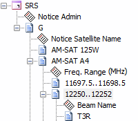
Browse ITU Databases
- Browse SNS Database Files supporting over 500 search fields
- Full integration of the ITU SNL Part-B database to quickly see the full filing history associated with any network
- Integrated access to the ITU SNL Part-C data to easily retrieve "as received" information
- Interrogate the UCS Satellite Database to retrieve information on operational satellites
- Search the Space-Track Database to retrieve Satellite Catalogue or TLE information on operational satellites
- Create your own custom search criteria to retrieve just the information that you need
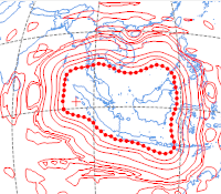
View & Edit Beam Data
- Import and edit gain contour, service area and AG/GSO diagram data from ITU GIMS database files
- Create and edit your own custom gain contour, service area and AG/GSO diagrams and save them into GIMS database format
- Generate contours automatically using the ITU APL from a baseline contour
- Graphically compare gain contour diagrams
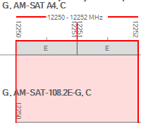
Frequency Plotter
- Import frequency data from ITU SNS database files
- Create your own custom frequency data
- Visually display frequency overlaps
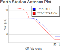
Earth Station Antenna Plotter
- Import Earth Station Antenna data from ITU SNS database files
- Create your own Earth Station Antenna data from the ITU Antenna Pattern Library, in-built patterns or completely custom data
- Visually display antenna plots
- Plot overlapping antenna data to easily compare antenna sidelobe performance
TLE Analysis
- Import two-line-element (TLE) data from Space-Track.org or manually from other sources such as Celestrak
- Analyse TLE including retrieving location data at the associated epoch date, or a prediction at any other custom date and time
- Visually display satellite ground track data
- Plot position data over time such as the longitude or altitude to understand when and how satellites are moving
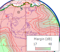
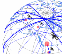
Coordination Analysis
- Support for downlink PFD analysis with built in Appendix 30 Annex 1, Appendix 30 Annex 4, Resolution 553, Resolution 554 and Article 21 limits
- Appendix 8, ΔT/T analysis
- Appendix 30B Annex 4 analysis
- C/I analysis including calculation of Margin, C/I, C0/I0, C/(N+I), C0/(N0+I0), I/N and I0/N0
- Import data from ITU SNS database files or create your own data including full control over beam gain contour, service area and test point data
- View graphical plots showing interference over the Earth's surface (or inside the relevant service area)
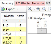
IFIC Processing
- Automate the processing of the bi-weekly IFIC databases to identify new networks which have the potential to cause interference to your filings
- Quickly retrieve and view the ITU findings
- Perform independent analysis of many of the ITU coordination triggers to validate the ITU's findings as well as examine in depth the reason for identification
- Supports Appendix 5, Appendix 8, Appendix 30 Annex 1 & Annex 4, Appendix 30A Annex 1 & Annex 4, Appendix 30B Annex 4 & No. 6.6 and Article 23.13B analysis